Examples of Erosion and Barrier Transgression on the U.S. East Coast
Roger N. Dubois
University of Maryland,
Baltimore County
Department of Geography
and Environmental Systems
1000 Hilltop Circle
Baltimore, MD 02120

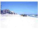
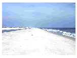 Beach berm that was overtopped by the swash of Hurricane Gloria
(October 1985). Swash has accumulated in the backshore. The beach
is located in the Delaware Seashore State Park, just south of Dewey
Beach, DE.
Beach berm that was overtopped by the swash of Hurricane Gloria
(October 1985). Swash has accumulated in the backshore. The beach
is located in the Delaware Seashore State Park, just south of Dewey
Beach, DE.
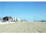
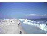
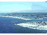
 During the winter along the Delaware coast, storm waves generated
by northeasters erode the beach and construct a longshore bar, upon
which a person is standing in this photo (April 1982).
During the winter along the Delaware coast, storm waves generated
by northeasters erode the beach and construct a longshore bar, upon
which a person is standing in this photo (April 1982).
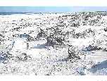
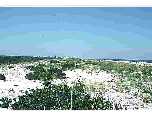 Foredune in the Delaware Seashore State Park. The elevation of the
foredune varies from 3 to 4 m above mean sea level (September 1988).
Foredune in the Delaware Seashore State Park. The elevation of the
foredune varies from 3 to 4 m above mean sea level (September 1988).
 Foredune in the Delaware Seashore State Park. The elevation of the
foredune has been reduced (see slide 3) by overwash. The irregular black beach
surfaces are zones of heavy mineral concentrations (October 1991).
Foredune in the Delaware Seashore State Park. The elevation of the
foredune has been reduced (see slide 3) by overwash. The irregular black beach
surfaces are zones of heavy mineral concentrations (October 1991).
 The shoreline of Ocean City, Maryland, has been eroding at an
average rate of about 1 m/yr. During the early 1980's, city officials
thought that the real estate along the beach could be protected
by building an artificial dune; a dune was constructed by bulldozing
beach sediments. This activity reduced the volume of beach material
which normally would have been available to absorb storm wave
energy (April 1982).
The shoreline of Ocean City, Maryland, has been eroding at an
average rate of about 1 m/yr. During the early 1980's, city officials
thought that the real estate along the beach could be protected
by building an artificial dune; a dune was constructed by bulldozing
beach sediments. This activity reduced the volume of beach material
which normally would have been available to absorb storm wave
energy (April 1982).
 The shoreline of Ocean City, Maryland, has been eroding at an
average rate of about 1 m/yr. During the early 1980's, city officials
thought that the real estate along the beach could be protected
by building an artificial dune (see slide 5). Storm waves badly eroded
the artificial dune. To protect this area from
further storm damage a different approach was initiated in the late
1980's. The beach has been artificially widened by dredging sediments
from the continental shelf and pumping them onto the beach. This slide,
taken in September 1988, was taken from about the same position as slide 5.
The shoreline of Ocean City, Maryland, has been eroding at an
average rate of about 1 m/yr. During the early 1980's, city officials
thought that the real estate along the beach could be protected
by building an artificial dune (see slide 5). Storm waves badly eroded
the artificial dune. To protect this area from
further storm damage a different approach was initiated in the late
1980's. The beach has been artificially widened by dredging sediments
from the continental shelf and pumping them onto the beach. This slide,
taken in September 1988, was taken from about the same position as slide 5.
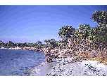 Beach erosion has occurred along this beach segment of Cayo Costa
Island, FL, as seen by the fallen palm trees resting on the beach
(April 1969).
Beach erosion has occurred along this beach segment of Cayo Costa
Island, FL, as seen by the fallen palm trees resting on the beach
(April 1969).
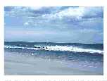
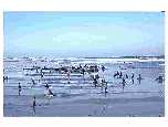
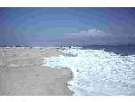 A minor storm is attacking the seaward side of a berm during a high
tide; the swash action is confined primarily to the seaward side of
the berm (July 1979).
A minor storm is attacking the seaward side of a berm during a high
tide; the swash action is confined primarily to the seaward side of
the berm (July 1979).
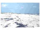
 A minor storm attacked the seaward side of this berm during high
tide (see slide 8). When the tide fell, a ~30 cm high beach scarp appeared
along this Delaware Beach (July 1979).
A minor storm attacked the seaward side of this berm during high
tide (see slide 8). When the tide fell, a ~30 cm high beach scarp appeared
along this Delaware Beach (July 1979).
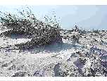
 The wind is blowing onshore from left to right in this slide. The
interaction among wind, sand, and beach grass tufts has caused
streamline features to form on this beach (Delaware). Sands have
been eroded from the windward side of the tufts while deposition
has occurred in the lee of the tufts where some dead grass have
been blown over (August 1986).
The wind is blowing onshore from left to right in this slide. The
interaction among wind, sand, and beach grass tufts has caused
streamline features to form on this beach (Delaware). Sands have
been eroded from the windward side of the tufts while deposition
has occurred in the lee of the tufts where some dead grass have
been blown over (August 1986).
 The wind is blowing onshore from right to left in this slide. This
slide was taken at about the same location as slide 10.
Interaction among wind, sand, and beach grass tufts has caused
streamline features to form on this beach (Delaware).
The wind is blowing onshore from right to left in this slide. This
slide was taken at about the same location as slide 10.
Interaction among wind, sand, and beach grass tufts has caused
streamline features to form on this beach (Delaware).
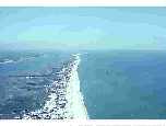
 Looking south at Cape Hatteras from the upper deck of the Cape
Hatteras Lighthouse (June 1980).
Looking south at Cape Hatteras from the upper deck of the Cape
Hatteras Lighthouse (June 1980).
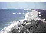
 Looking north along the shoreline of Assateague Island, Maryland.
To the left of the barrier island is Sinepuxent Bay. The offset of
the barrier in the upper part of the view is caused by the jetties at Ocean City
Inlet, which trap the southerly flowing littoral drift. In response
to a relative sea level rise of about 2 mm/yr. The barrier has been
transgressing at an average rate of 1 m/yr. Storm overwash transport
sediments from the seaward side of the barrier to the bay side (April 1982).
Looking north along the shoreline of Assateague Island, Maryland.
To the left of the barrier island is Sinepuxent Bay. The offset of
the barrier in the upper part of the view is caused by the jetties at Ocean City
Inlet, which trap the southerly flowing littoral drift. In response
to a relative sea level rise of about 2 mm/yr. The barrier has been
transgressing at an average rate of 1 m/yr. Storm overwash transport
sediments from the seaward side of the barrier to the bay side (April 1982).
 Near Assateague Island, Maryland, we can see that some time in the
past 100 years or so, a severe storm cut through the barrier to
create an inlet and a flood tidal delta in the bay. The inlet has
since closed by the delta and its main channel can still be seen.
When the inlet was open, it provided an avenue by which sediments
on the seaward side of the barrier could be effectively transported
into the bay (April 1982).
Near Assateague Island, Maryland, we can see that some time in the
past 100 years or so, a severe storm cut through the barrier to
create an inlet and a flood tidal delta in the bay. The inlet has
since closed by the delta and its main channel can still be seen.
When the inlet was open, it provided an avenue by which sediments
on the seaward side of the barrier could be effectively transported
into the bay (April 1982).
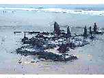 During barrier transgression, storm waves transport sediments from
the seaward side to the bay side. In time the bay side vegetation may
be covered by washover deposits. Eventually as the barrier continues to
transgress, the bared vegetation is exposed along a foreshore following
storm conditions. This view (March 1982) shows exposed peat and tree
stumps (20 to 40 cm in height) at a beach in the Delaware Seashore
State Park.
During barrier transgression, storm waves transport sediments from
the seaward side to the bay side. In time the bay side vegetation may
be covered by washover deposits. Eventually as the barrier continues to
transgress, the bared vegetation is exposed along a foreshore following
storm conditions. This view (March 1982) shows exposed peat and tree
stumps (20 to 40 cm in height) at a beach in the Delaware Seashore
State Park.
 This view (January 1983) was taken at the same location as slide 15
in the Delaware Seashore State Park. Peat and tree stumps along the
Atlantic foreshore of Delaware are primarily exposed during the winter
months when storm waves erode beach sediments and deposit them in the
nearshore. During the summer months, when swells prevail, the sand berms
reform and cover the peat and stumps.
This view (January 1983) was taken at the same location as slide 15
in the Delaware Seashore State Park. Peat and tree stumps along the
Atlantic foreshore of Delaware are primarily exposed during the winter
months when storm waves erode beach sediments and deposit them in the
nearshore. During the summer months, when swells prevail, the sand berms
reform and cover the peat and stumps.
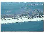
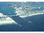
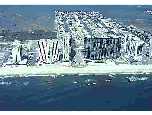
 View of Ocean City Inlet, Maryland (April 1982). This inlet was
cut during a hurricane in 1933. In order to stabilize the inlet for
commercial fishing, jetties were built and completed in 1935. Because
littoral drift flows southward (right to left), deposition has been
extensive along a beach segment north of the jetties. South of the
jetties, the north end of Assateague Island, which is in a Maryland
State park, has been severely eroded.
View of Ocean City Inlet, Maryland (April 1982). This inlet was
cut during a hurricane in 1933. In order to stabilize the inlet for
commercial fishing, jetties were built and completed in 1935. Because
littoral drift flows southward (right to left), deposition has been
extensive along a beach segment north of the jetties. South of the
jetties, the north end of Assateague Island, which is in a Maryland
State park, has been severely eroded.
 View of the Indian River Inlet located in the Delaware Seashore State
Park (April 1982). The barrier shown is a bay mouth barrier. In this
general area, inlets have opened and closed throughout the nineteenth
and early twentieth century. To stabilize the inlet, jetties were built.
The project was completed in 1939. In this view the littoral drift flows
north (left to right) so that beach progradation has occurred south
of the jetties while beach erosion has taken place north of the jetties.
The eroding beach threatened the integrity of Delaware Highway 1, which
is the only north-south road on the barrier. In the past sediments were
dredged from the pond in the upper right of this view and piped to the
eroding beach.
View of the Indian River Inlet located in the Delaware Seashore State
Park (April 1982). The barrier shown is a bay mouth barrier. In this
general area, inlets have opened and closed throughout the nineteenth
and early twentieth century. To stabilize the inlet, jetties were built.
The project was completed in 1939. In this view the littoral drift flows
north (left to right) so that beach progradation has occurred south
of the jetties while beach erosion has taken place north of the jetties.
The eroding beach threatened the integrity of Delaware Highway 1, which
is the only north-south road on the barrier. In the past sediments were
dredged from the pond in the upper right of this view and piped to the
eroding beach.
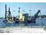 View of a dredge used near the Indian River Inlet, Delaware Seashore State
Park (May 1982). Erosion threatened the integrity of Delaware Highway 1, which
is the only north-south road on the barrier (see slides 17 and 18). In the past sediments were
dredged from a pond and piped to the eroding beach. The dredge used in this
operation is shown here. Since 1990 a fixed plant sand-by-passing
system located at the inlet has replaced the pond dredging operation.
View of a dredge used near the Indian River Inlet, Delaware Seashore State
Park (May 1982). Erosion threatened the integrity of Delaware Highway 1, which
is the only north-south road on the barrier (see slides 17 and 18). In the past sediments were
dredged from a pond and piped to the eroding beach. The dredge used in this
operation is shown here. Since 1990 a fixed plant sand-by-passing
system located at the inlet has replaced the pond dredging operation.
 View of Cape May, NJ (April 1982). The littoral drift is from
the north to the south (top to bottom). At the top of this view one
can see the Cape May Inlet with jetties; deposition has occurred
north of the jetties while erosion has taken place south of the
jetties. Several groins line the shore of Cape May itself. The most
southern groin is the largest and has trapped a great deal of sediment;
south of this groin the beach has extensively eroded.
View of Cape May, NJ (April 1982). The littoral drift is from
the north to the south (top to bottom). At the top of this view one
can see the Cape May Inlet with jetties; deposition has occurred
north of the jetties while erosion has taken place south of the
jetties. Several groins line the shore of Cape May itself. The most
southern groin is the largest and has trapped a great deal of sediment;
south of this groin the beach has extensively eroded.
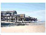 Homes have been built very close to the Maryland and Delaware
beaches. At South Bethany Beach, Delaware, single family homes are
permitted to be built directly on the beach as shown in this slide
taken at low tide (April 1984). A person is standing on exposed peat,
which suggests that this barrier is transgressing.
Homes have been built very close to the Maryland and Delaware
beaches. At South Bethany Beach, Delaware, single family homes are
permitted to be built directly on the beach as shown in this slide
taken at low tide (April 1984). A person is standing on exposed peat,
which suggests that this barrier is transgressing.
 At South Bethany Beach, Delaware, single family homes are
permitted to be built directly on the beach. Small to moderate
northeasters usually do not cause major damage to these homes, but
overwash does at times cause damage to the road that runs parallel
and directly behind the homes (April 1984). In addition, water and
sewer pipes that run under the road and to the homes have been
exposed and are vulnerable to damage.
At South Bethany Beach, Delaware, single family homes are
permitted to be built directly on the beach. Small to moderate
northeasters usually do not cause major damage to these homes, but
overwash does at times cause damage to the road that runs parallel
and directly behind the homes (April 1984). In addition, water and
sewer pipes that run under the road and to the homes have been
exposed and are vulnerable to damage.
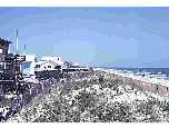 View of the shore near Fenwick Island, Delaware (May 1982).
Property owners have not been permitted to build on the beach or on
the foredune in this area. Sand fences have been erected along the
foredune to induce deposition and to keep people off the dunes.
View of the shore near Fenwick Island, Delaware (May 1982).
Property owners have not been permitted to build on the beach or on
the foredune in this area. Sand fences have been erected along the
foredune to induce deposition and to keep people off the dunes.
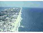
 Condominiums and hotels have been built on the foredune
while single family units have been built on bay marshes in this
photo taken in Ocean City, Maryland (April 1982).
Condominiums and hotels have been built on the foredune
while single family units have been built on bay marshes in this
photo taken in Ocean City, Maryland (April 1982).
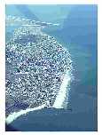
 Viewing north at sand waves along the Outer Banks near Whale Bone
Junction, NC. The water body at the upper left of the barrier is
Albemarle Sound. The sand body at the far north extent of the
barrier is Jockey's Ridge (June 1981).
Viewing north at sand waves along the Outer Banks near Whale Bone
Junction, NC. The water body at the upper left of the barrier is
Albemarle Sound. The sand body at the far north extent of the
barrier is Jockey's Ridge (June 1981).
Return to the Table of Contents